Showing 35 items matching mt beauty land
-
 Kiewa Valley Historical Society
Papers - Hollonds' Family and their memories, 2013
... mt beauty land... cattlemen mt beauty land tawonga boarding house ...The Hollonds' family were original settlers in the Kiewa Valley at Mulagong. Their descendants owned land in Tawonga, Tawonga South and between the East and West of the Kiewa river. Hollonds had a cattle run on Mt Fainter which was later given to the Hicks family.Members of the Hollonds family lived, worked and married in the Kiewa Valley. These papers describe the connection to the families and the Kiewa Valley.Typed papers donated by the Hollonds' family covering: The Hollonds Family History, Cattlemen, 'Snowy' Miller, Mrs Hollonds' Boarding house, SEC Depot at Tawonga, building of Bogong Township, Early Scenes on the Kiewa Scheme.hollonds family, tawonga station, cattlemen, mt beauty land, tawonga boarding house -
 Kiewa Valley Historical Society
Papers - Mt Beauty Airport Development
... for an airstrip in Mt Beauty in 1965. The land was owned by the SEC... for an airstrip in Mt Beauty in 1965. The land was owned by the SEC ...The SECV began investigating four possible sites for an airstrip in Mt Beauty in 1965. The land was owned by the SEC and leased by Mr J. Sharp. It became available on the condition that the land would only be available to the Municipal shire. This land was officially opened as an Airport as an official tourist activity in 1977. It continues to be available to tourists, fire fighters, the air ambulance and the local gliding club.The opening of Mt Beauty Airport has enhanced Mt Beauty township by enabling fire fighters to access the surrounding bush during bush fires, by enabling Ambulance helicopters to rush emergency patients to city hospital, by giving tourists the opportunity to fly in and to give the local Gliding Club the opportunity to store and fly their gliders. 1. Set of papers titled 'History Mt Beauty Airport Development' held together by large steel clip by Alex McCullough. 2. Set of papers titled 'Department of Transport' and 'Alpine Shire' both held together by one staple. 3.Mt Beauty Township Survey Plan of Airstrip 1975 4. Large folder titled Mr J. R. Sharp 1975 - Mt Beauty Airfieldmt beauty airport history, alex mccullough, transport, tourism -
 Kiewa Valley Historical Society
Photograph Farm Land, Mount Beauty Acreage before Golf Course, Circa 1950
This photograph is a "snap shot" in time circa 1950s detailing the rural environment before the effects of the Kiewa Valley Hydro Scheme altered the basic rural setting of the valley. The golfing fairway was being mapped out on previous grazing land, before the laying of a golf course, for use by the construction workers and auxiliary administration employees of the Victorian State Electricity Commission. This photograph details a dramatic period in time which saw an enormous change to the exclusively rural area of the Kiewa Valley region in the mid 1900s. This change presented both physical and mental challenges to the existing quiet rural inhabitants of the valley. The State of Victoria had to make adjustments to the changing demands imposed by population and industrial expansions. The development of cleaner energy supplies to a growing population has its downside ,which ever way the intrusion into the "natural" landscape is made.Black and white photograph detailing surveyor posts for construction of golf course. Land used, before establishment of the Mount Beauty Village, as farming/grazing cattle and viewed towards Mount Bogong and its Alpine ranges. The photo is on 200gms paper and not on photographic paper.nilmount beauty in the 1940s - 1950s, grazing in the kiewa valley, sec victoria -
 Kiewa Valley Historical Society
Photograph of Kiewa Valley Panorama, Farming lands within the Kiewa Valley in1950s, Circa 1950
This photograph shows how (early to mid1900s), before the establishment of the Mount Beauty "gated" village, the Kiewa Valley was farmed and the scarce population was spread out over acres of productive land. This photograph catches a time before (what appeared to the local farmers as the invasion by a mass of construction workers) when this remote valley was part of a "lay back" rural landscape,occasionally visited by friends and some wayward tourists. The mountain ranges provided an adequate barrier against the way-would traveller. The immigration numbers coming into Australia was still quite small ( due to the "white" Australia policy) which was in force before World War II. After World War II a mass of displaced European refugees and migrants boosted the Australian population and provided for a greater degree of diverse professions and rural related work force.This photograph depicts the borderline in time between an exclusively rural based population and respective activities(early 1900s)to the present (2000 on wards) integrated village, tourist and retiree/holiday area. The time when land was exclusively used in agriculture is over and the impact of cheaper rural produce from Asian markets will see a shift of land useage and population activities. The Kiewa Valley is loosing its hiding place and is becoming more and more a source of untapped residential land. Black and white photograph of farming/grazing land useage, before the establishment of the Mount Beauty Village. Small pockets of residentual houses can be viewed. Road access (unsealed dirt) was typical of that provided in rural regions in the 1950s. The photo is on 200gms paper and not on photographic paper.kiewa valley in the early1900s, grazing in the kiewa valley, sec victoria -
 Kiewa Valley Historical Society
Black and White photograph of Road Making Machinery, Kiewa Road Making 25/08/1938 No. 2, 25/08/1938
Construction of the main road from South Tawonga to the Bogong High Plains, to provide access to the construction sites for the new Kiewa Hydro Electric Scheme, was commenced early in 1938, the work being undertaken on behalf of the commission by the Country Roads Board. For the construction work, the Commission purchased three Caterpillar - model R07 - diesel crawler tractors equipped with Kay Brunerei (Brunner) hydraulically operated trailbuilders (angle dozers). This acquisition resulted from a visit to the United States of America in May, 1937 by the Construction Engineer ( Mr. C.H. Kernot) and Assistant Civil Engineer ( Mr. J.F. Douglas) where they saw this relatively new type of equipment in use. With the co-operation of the CRB, the Commission demonstrated the operation of these machines at Fishermen's Bend on 6th April, 1938. They were then sent to Kiewa where they commenced operation towards the end of the month. From South Tawonga, the route let immediately across the Western Branch of the Kiewa River necessitating the construction of a bridge 100 feet long. By the end of 1939, the excavation had been 'opened up' for a distance of 19 1/2 miles (approx. 31 km.) and of this length, 10 miles (approx. 16 km.) had been surfaced. (see KVHS 0328)The purchase of this type of mechanical equipment in road making was a huge investment, as prior to this most of the work would have been done manually with the use of picks and shovels. Not only were many months of hard manual labour saved, but a very significant amount of time in providing access to the proposed work sites for the new Kiewa Hydro Scheme. This photo is an excellent reminder of how primitive the early machinery was compared to the present but also represents the forward thinking of the State Electricity Commissions engineers in purchasing such innovative equipment.A black and white photograph of road making near Mt. Beauty in 1938. Mount Beauty hills can be seen in the background with cleared land for grazing in the fore ground.Hand printed in black ink at the top of the photograph is 'Kiewa Road Making 25/8/1938'. On the right hand corner has been printed the number 2. It has been printed on gloss Velox paper.road making, state electricity commission, caterpillar tractor, kiewa, secv -
 Kiewa Valley Historical Society
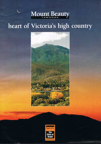
Poster Brochure, Mt Beauty Tawonga Heart Of Victoria's High Country, Circa 1995
The Item is a pictorial time piece of the valley and usage, farms,industry,town area, vegetation and winter snow levels Historical and the social-economical development at circa 1995 of land usage and residential buildings style.Major social events e.g. Festival of the Bogong Moth and the Mt Beauty Mardi Gras. It is also a good historical record of tourism campaigns of the Alpine Shire and Mt Beauty Chamber of Commerce. Also see "KVHS 0125"Brochure folds out from a 20.5cm x 29.5cm to 82cm x 29.5cm poster type documentinside panoramic photo of snow tipped alpine mountain range incorporating the Mount Beauty township, farming area of the Kiewa Valley and relevant tourist orientated informationtourism mt beauty tawonga photographs, victorian alps -
 Kiewa Valley Historical Society
Photograph of Kiewa Valley Panorama, Kiewa Valley from No. 5 Road, Before 1945
In 1943 a camp for workmen was erected and a commencement made with the erection of plant storage and workshop buildings in the new township of Mt. Beauty. The photograph was probably taken after the completion of these buildings. There is no sign of construction of the town itself. In the latter part of 1945 work was commenced on the Mt. Beauty township area with a medical centre, general trading store and some houses under construction. The No. 5 Road, from where the photograph was taken, is the road to West Kiewa Power Station and Big Hill Scenic Lookout.Is an excellent view of the Kiewa Valley before there was little work undertaken to establish the town of Mt. Beauty. Farming was well established with the evidence of huge areas of cleared land. The junction of the East and West Kiewa Rivers can be clearly seen. The first Workmen's camp is near the river and some workshop buildings can also be seen. Black and white photograph of the Kiewa Valley, looking North.Handwritten on the back of photograph "Kiewa Valley from No. 5 Road".kiewa valley, camp, buildings, mt. beauty -
 Kiewa Valley Historical Society
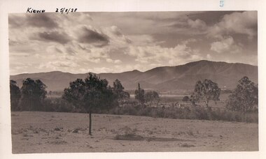
Black and white photograph of farmland, Kiewa, 25/8/38, circa 1938
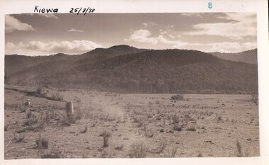
... as it was before the establishment of the town of Mt. Beauty. The land has ...This photograph was taken in August, 1938 some eight years prior to the establishment of Mt. Beauty as a township. The area was still being used for grazing, and the land was eventually acquired from the local land owners by the State Electricity Commission. The construction of the road, from Tawonga to the High Plains, was commenced in April of this year. This allowed men and heavy equipment to be transported to the work sites for the construction of the Kiewa Hydro Electric Scheme This photograph is important as it shows the upper Kiewa Valley as it was before the establishment of the town of Mt. Beauty. The land has been cleared of natural growth and has been used for grazing cattle. By 1946 housing construction had commenced for the new town of Mt. Beauty and by 1948 street construction in the southern part of the town was completed as far as Hill Street.A black and white photograph of farmland with Mt. Emu in the background. This has been taken from where Mt. Beauty township now stands prior to road making and the erection of houses. A line of trees below the hill line indicates the position of the East Kiewa River. (No. 5 in a set of 8) Handwritten in black ink on the upper left corner of the photograph is the inscription 'Kiewa 25/8/38' and the number 5 has been stamped on the upper right hand corner. On the back is the word 'Velox' which is the name of the photographic paper on which the photo was developed.road construction, kiewa, tawonga, mt. beauty, secv -
 Kiewa Valley Historical Society
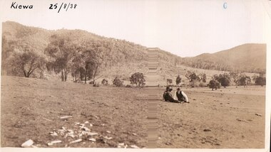
Black and white photograph of farmland, Kiewa, 25/8/38, circa 1938
... the establishment of the town of Mt. Beauty. The land had been cleared ...This photograph was taken in August, 1938 at the time of road making in the area and some eight years prior to the establishment of Mt. Beauty township. The area was still being used for grazing, and the land was eventually acquired from the local land owners by the State Electricity Commission. The construction of the road, from Tawonga to the High Plains, was commenced in April of this year. This allowed men and heavy equipment to be transported to the work sites for the construction of the Kiewa Hydro Electric Scheme. An important photograph as it shows the upper Kiewa Valley as it was before the establishment of the town of Mt. Beauty. The land had been cleared of natural growth and has been used for grazing cattle. By 1946 housing construction had commenced for the new town of Mt. Beauty and by 1948 street construction in the southern part of the town was completed as far as Hill Street.A black and white photograph taken in the upper Kiewa Valley showing farmland with a group of three unidentified people sitting on the grass.Handwritten in black ink is the inscription 'Kiewa 25/8/1938'. In the right corner of the photograph has been stamped the number 6. On the back in a circle, some 14mm across, are the words 'Kodak Print'. The word Velox is also printed on the back.kiewa, mt. beauty, construction, grazing, secv -
 Kiewa Valley Historical Society
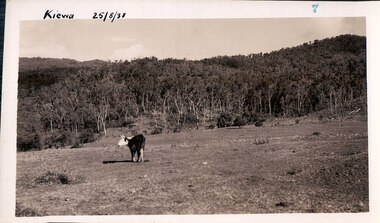
Black and white photograph of farmland, Kiewa, 25/8/38, circa 1938
... of the town of Mt. Beauty. The land has been cleared of natural ...This photograph was taken in August, 1938, some eight years prior to the establishment of Mt. Beauty a a township. The area was still being used for grazing, and the land was eventually acquired from the local land owners by the State Electricity Commission. The construction of the road, from Tawonga to the High Plains, was commenced in April, 1938 and this photograph was taken August, 1938. This allowed men and heavy equipment to be transported to the work sites for the construction of the Kiewa Hydro Electric Scheme. Prior to this access was by bridle trail, either on horse back or on foot. By 1946 housing construction had commenced for the new town of Mt. Beauty and by 1948 street construction in the southern part of the town was completed as far as Hill Street.This photograph is important as it shows the upper Kiewa Valley as it was before the establishment of the town of Mt. Beauty. The land has been cleared of natural vegetation to allow grazing of cattle. Black and white photograph of grazing farmland with one animal standing in the paddock. The area could possibly be where the golf course now stands with the road to the high plains not yet commenced.Handwritten in the upper left hand corner 'Kiewa 25/8/38'. The number 7 has been stamped in the upper right hand corner. It is part of a set of 8 photographs. On the back are the words Velox repeated several times, indicating the type of photographic papergrazing, kiewa, mt. beauty, secv -
 Kiewa Valley Historical Society
Photograph Farm Land, Kiewa, 25/8/38, circa 1938
This photograph was taken in august, 1938 some eight years prior to the establishment of Mt. Beauty as a township. The area was still being used for grazing cattle and the land was eventually acquired from the local land owners by the State Electricity Commission. The construction of the road, from Tawonga to the High Plains, was commenced in April of 1938. This allowed men and heavy equipment to be transported to the work sites for the construction of the Kiewa Hydro Electric Scheme. Prior to this access was by bridle trail, either on horse back or by foot. By 1946 housing construction had commenced for the new town of Mt. Beauty and by 1948 street construction in the southern part of the town was completed as far as Hill Street.This is an important photograph as it shows the upper Kiewa Valley and the site for Mt. Beauty as it was before the establishment of the town. The land has been cleared of natural vegetation and used for grazing cattle.Black and white photograph of farmland, cattle in the distance, hills in the backgroundHandwritten in the upper left hand corner, in black ink, 'Kiewa 25/8/38'. The number 8 has been stamped in the upper right hand side of the photograph. On the back have been stamped the words Velox, indicating the type of photographic paper.kiewa, mt. beauty, construction, grazing, secv -
 Kiewa Valley Historical Society
Magazine - Nature, Joseph Swanson Wilkinson, Wild Life Australian Nature Magazine, January 1949
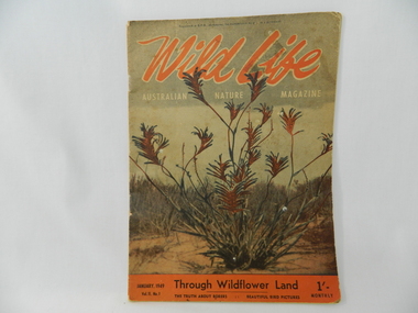
This magazine was part of the Bogong School's library and represents an important aspect of the school's curriculum.Bogong School was noted for having a great interest in nature and conservation. 48 page soft covered magazine. Cover with limited colour including orange, black, white and brown with green. Inside pages in black, brown and grey pictures with black print on off white pages. Page 41 is in cartoon form. 'Registered at G.P.O. Melbourne for transmission by post as a periodical'. written in black in tiny print across the top. 1st line: 'Wild Life' in orange with white outline. 2nd line: 'Australian Nature Magazine' in white underneath title. All across top. 3rd written line: 'January, 1949 Through Wildflower Land 1/-' underneath picture of Kangaroo Paw. in black Underneath this writing follows: 4th line: 'Vol.11 No. 1 The Truth About Borers : : Beautiful Bird Pictures' in black Underneath 1/- is 'Monthly' Background behind black writing is orange same as title.bogong primary school. bogong. wild life. nature. -
 Kiewa Valley Historical Society
Newspaper Article - Thomas Briggs, 5th March 1988
Thomas Briggs was a pioneer of the Tawonga District. He worked on his parent's farm, selling goods, droving pigs and travelling to Yackandandah and Bright. He worked with pick and shovel on the Tawonga to Bright Road in 1902. He took up 320 acres of wild forest in Tawonga at 10 cents per acre per year for 20 years. He built a slab and shingle hut and a boundary fence. In 1886 he married Annie Maria Platt parenting 5 sons and 2 daughters until Annie died in 1953, aged 86 years.Thomas Briggs was a pioneer living in the Kiewa Valley with his parents and then with wife and family. This article is a history of his life from 1862 until 1887. See KVHS 0850 for information on the dray used to make the Tawonga Gap road - owned by John Briggs.Newspaper article Page 34 Border Morning Mail, Saturday, March 5, 1988 - Thomas Briggs Born 3rd Nov. 1862 who lived with his family at Upper Gundowring. His travels in the area including the Tawonga Gap and its construction in 1902 and his taking up of land in Tawonga in 1880. The article finishes in 1887 when he married Annie Maria Platt. The Thos Briggs story continues next week.thomas briggs; tawonga; kiewa valley; annie platt -
 Kiewa Valley Historical Society
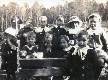
Photo - Tawonga Primary School pupils 1920, 1920
Tawonga Primary School Children 1920. Tawonga is in the Kiewa Valley where farmers lived with their families. The school was opened on 27th July 1880 situated on 8 acres near the current township of Tawonga. This school was erased by fire in 1900 and all records were destroyed. The school then moved to the old Tawonga Hall. In 1910 the school was shifted to its present site on 3 acres of land donated by Frank Cooper. The school building and attendance continued to grow especially during the construction of the Kiewa Hydro Electric Scheme. Early residents of the area. Ellie Seymour front row first on left. Walter J E Ryder in front of the desk at right. Vera Ryder behind him on the right. The boys also wore white collarsCopy of black and white photograph of pupils (children) at Tawonga Primary School 1920tawonga primary school, state school, kiewa valley -
 Kiewa Valley Historical Society
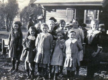
Photo - School Children Tawonga Primary School, Circa 1920 (estimate)
Tawonga is in the Kiewa Valley, where local farmers lived with their families. The school was originally opened July 27 1880, situated on 8 acres near the current township of Tawonga. The school was erased by fire in 1900 and all records destroyed. The school was then moved to the Old Tawonga Hall. In 1910, the school was shifted to its present site on 3 acres of land donated by Frank Cooper. The school building and attendance continued to grow, especially during construction of the Kiewa Hydro Electric Scheme.Tawonga Primary School has educated the local farming and town children for many years. It is an excellent source of the names of the local families of the time ie: Vera Ryder – front row, far right (little girl with the wide headband.)Copy of black and white photograph of pupils at Tawonga Primary School. Circa 1920 (estimate)tawonga primary school, kiewa valley -
 Kiewa Valley Historical Society
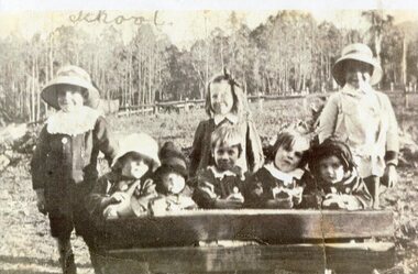
Photo - School Children Tawonga Primary School, Circa 1920 (estimate)
Tawonga is in the Kiewa Valley, where local farmers lived with their families. The school was originally opened July 27 1880, situated on 8 acres near the current township of Tawonga. The school was erased by fire in 1900 and all records destroyed. The school was then moved to the Old Tawonga Hall. In 1910, the school was shifted to its present site on 3 acres of land donated by Frank Cooper. The school building and attendance continued to grow, especially during construction of the Kiewa Hydro Electric Scheme.Tawonga Primary School has educated the local farming and town children for many years. It is an excellent source of the names of the local families of the time. Copy of black and white photograph of pupils at Tawonga Primary School. Circa 1920 (estimate)tawonga primary school, kiewa valley -
 Kiewa Valley Historical Society
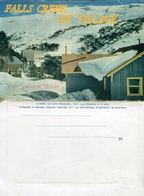
Souvenir Postcard Folder – Falls Creek Ski Village
After World War II, the Kiewa Hydroelectric Scheme was started in the Kiewa River valley by the State Electricity Commission of Victoria. On land previously used only for summer cattle grazing in the natural alpine grasslands, the first ski lodge was built in 1948 by workers from the scheme. The first lift, a rope tow, was built in 1951 and the first chairlift in Australia was constructed there in 1957. Falls Creek Post Office opened on 9 June 1958 (with telegraph and telephone facilities only until 1964) .Despite strong opposition from the head of the Kiewa scheme, who didn't want tourists clogging up his roads and destroying his "dry" construction camps by bringing in booze, Falls Creek boomed as much as Hotham, partly owing to its relatively good access road. Early lodges included Bogong (c.1946), Skyline (1947), Albury (1949), Myrtleford (1949) and Dawn (c.1950).The souvenir postcard photographed and produced by an enterprising local businessman Mr S K Pearce, was produced as a memento for skiers and other visitors to the Falls Creek and Mt Beauty area to send to family and friends as a reminder of their visit to the region, or to keep as a personal souvenir. It presented an excellent promotional opportunity for enterprising local businessmen to promote the area to skiers and tourists near and far. It also presents an excellent pictorial history of the falls creek area around the late 1950’s to early 1960’sColour postcard folder (unused) containing 13 photographs of the Falls Creek ski area and surrounds. Inside cover has a brief description of the area and the services available to visitors Printed on front cover- FALLS CREEK SKI VILLAGE. Your Souvenir Folder Photo of skiing slopes of the village Inside front flap - a brief description of the Falls Creek area and the services available to visitors 1. Diana Lodge parking area and Spion Kopje 2. Winterhaven Lodge 3. Ski Hirage Centre and skiing slopes 4. Ski Lodges from main road 5. Nelse and Arundel Lodges 6. Day visitors’ shelter and parking area 7. Summit T-Bar lift 8. Spur T-bar looking towards Village and Spion Kopje 9. T-bar lower station and Snow Crystal Inn 10. ‘Akja’ rescue sled in use 11. Falls Creek road and Grand Coeur Lodge annex 12. Rope tows and beginner slopes 13. Back cover- Published by Nucolorvue Pty Ltd Mentone Vic. Printed in Australia For S.K.Pearce Pty Ltd Tawonga and Mt Beauty falls creek, snow, bogong high plains, victorian alps -
 Kiewa Valley Historical Society
Report - Alpine Study Area Volume 2 Maps, Land Conservation Council, 1970s
The Victorian Environmental Assessment Council and the former Environment Conservation Council (ECC) and Land Conservation Council (LCC) have completed 36 land use investigations over more than 35 years, including 27 regional reviews. They provide a framework for use of Public Land in Victoria. The Land Conservation Council was established by the Land Conservation Act 1970.These maps provide an assessment of the Alpine area at the time the maps were created. Some of the topics eg. Rainfall and water resources may change over the years thus providing a comparative analysis. Others may provide information for future development such as mineral exploration, building of a dam / tunnel etc.Blue box shaped folder containing 9 of 10 Maps of the Alpine Study Area produced by the Land Conservation Council. Maps include 1. Public land and descriptive blocks. 2. Physiography. 3. Topography. 4. Geology (missing). 5. Rainfall and water resources. 6. Vegetation 7. Land systems. 8. Recreation. 9. Primary production. 10. Minerals Ex library item. Stamped in red "Discarded From Stock / Swan Hill Regional Libraryalpine area, maps of alpine area, land conservation council -
 Kiewa Valley Historical Society
Report - Alpine Area Proposed Recommendations, Land Conservation Council, Victoria Melbourne, April 1978
The Land Conservation Council was established by the Land Conservation Act 1970. It makes recommendations to the Minister for Conservation with respect to the use of public land. Notices showing the boundary of the study area ... published in the Victorian Government Gazette Sept. 1973. A descriptive report was published in July 1977. Submissions (1538) on the future use of public land were received & included those representing a wide cross-section of the community. These were considered in the final report.Of interest for research on the changing ideas regarding the use of public land and the environment.Blue book bound by dark blue cloth tape. It has 92 pages with maps at the end and an empty folder inside the back cover.alpine area, land conservation council, alpine study area report -
 Kiewa Valley Historical Society
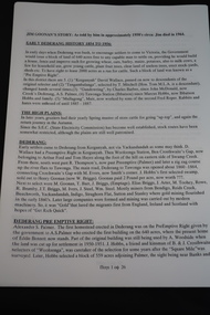
Papers - Jim Goonan's Story - Dederang, 1950's
Early settlers came to Dederang from Kergunyah. The main road, Dederang to Tawonga was opened about 1860 - 1864, connecting 'Crosthwaite's Gap' with 'Smith's corner'. Jim Goonan's ancestors selected land between Dederang and Tawonga in the early 1860's.A comprehensive history of the town of Dederang from the 1860's up to the 1950's. Early settlers, infrastructure, businesses, activities including sport and life style are described giving an insight into how the Kiewa Valley developed during this time.26 typed pages of the History of Dederang. Each page consists of paragraphs with a heading.dederang, jim goonan, kiewa valley -
 Kiewa Valley Historical Society
Report - Land Conservation Council x2, Land Conservation Council, Victoria Melbourne, April 1978, October 1974
... Centre 31 Bogong High Plains Rd Mt Beauty high-country Report ...Land Conservation Act 1970 established the Land Conservation Council to investigate and recommend to the Minister use of public land in Victoria. It describes and assesses the natural resources:-Physiography, Geology, Topography, Land Systems, Outdoor Recreation, Public land and blocks. Primary Production. Vegetation.North East Victoria includes the Kiewa Valley. This report gives an understanding of the development of the area.Thick heavy book with 312 pages with black and white photos. Back half has a folder with heavy cardboard attached to thick cardboard back cover. Inside folder are 9 maps with color each with a different title.Stamped on Front Cover: "Mount Beauty High School" Has a library borrowing slip at the back of the last page.land conservation council, environment, public land, kiewa valley, planning -
 Kiewa Valley Historical Society
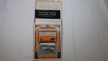
Journals - Department of Agriculture, 1. 1950s and 2. one 1932 & others 1970s
The Kiewa Valley has been a farming district from early settlement of white people. This has continued until the present although the nature of farming has varied over the years. Access to information has improved with transport and technology. The journals kept the farmers informed and up to date.These booklets and journals were one of the few sources of information during the 1950s for the isolated farmers of the Kiewa Valley. The Kiewa Hydro Electric Scheme improved both transport and technology during the scheme's construction from the 1940s. It provided the township of Mt Beauty at the upper end of the valley where shops and schools were constructed, roads were improved out of the valley and the supply of electricity for milking etc. became available. 1. 14 articles each bounded by 2 staples, and each reprinted from Dept. of Agriculture Journal on a particular topic relating to Agriculture. All black & white and c1950s. 2. 4 Journals with colored covers 3 from Victoria Dept. of Agriculture (1932, 1974 & 1975) and 1 from Sth. Australia.1. "J.H.Wallace" hand written top right corner of covers of pamphlets titled 'Diseases Affecting /Young Cattle' and 'Mastitis'. "AHW" hand written top right corner of cover of pamphlet titled ' Grading Land for Irrigation' 2. Nonefarming, agriculture, cattle, pasture, kiewa valley, department of agriculture in victoria, kiewa hydro electric scheme, -
 Kiewa Valley Historical Society
Book - Mt Beauty Voters' Roll, Shire of Bright - Voters' Roll 1979 - Mt Beauty Riding, 1979
Electoral roles list people who are registered and eligible to vote at federal, state, territory and local government elections and referenda. Prior to 1990 the rolls list voters in alphabetical order by surname and first names within each Sub-division of an electoral Division of each State or Territory. The roll is useful and interesting for family historians and the study of demographics.Electoral rolls help to locate the residential address of a person in a particular year or over a period of years. They can be used as a substitute for census records for family historians and the history of a particular place, in this case Mt Beauty. Alex McCullough was a resident of Mt Beauty and Councillor in the Bright Shire. 40 pages of firm blue paper with black typed print on one side only in 'landscape' format. Held by three staples. Each page has columns - numbered 1 to 656; Surnames in alphabetical order; Given names; Occupation; Includes L = 'land'; Address followed by Lot number in the Parish of WermatongOn the cover, top right hand corner "Cr McCullough"shire of bright; mt beauty riding; voters roll; parish of wermatong; alex mccullough -
 Kiewa Valley Historical Society
Book - Kiewa Voters' Roll, Shire of Bright - Voters' Roll 1979 - Kiewa Riding, 1979
Electoral rolls list people who are registered and eligible to vote at federal, state, territory & local government elections and referenda. Prior to 1990 the rolls list voters in alphabetical order by surnames & first names within each Sub division of an electoral division of each State or Territory. The roll is useful & interesting for family historians and the study of demographics. Alex McCullough lived in the Shire of Bright and was on its Council. Electoral roles help to locate the residential address of a person in a particular year or over a period of years. They can be used as a substitute for census records for family historians and the history of a particular place in this case the Kiewa Valley - Tawonga and Tawonga South.Approx. 60 pages of firm yellow paper with black typed print on one side only in 'landscape' format. Held by three staples. Each page has column - numbered 1 to 943; Surnames in alphabetical order; Given names; Occupation; includes L (=land). Address followed by Lot number and parish. Includes Tawonga and Tawonga SouthOn the cover on the right hand side handwritten and difficult to read - "Jack? / Indi / Benambra / Nth Eastern / Division? of Dawson / 123 Victoria Rd. / Melbourne 3000"shire of bright; kiewa riding; voters roll; alex mccullough; tawonga; tawonga south -
 Kiewa Valley Historical Society
Maps of Victoria
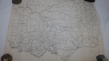
Three maps: copies from the 19th century. 1. Handwritten 'Dept of Lands & Survey 1876'. 2. Map of the Ovens & Murray District, Victoria with handwritten 'F.H. Hiscock & Co's, New Victoria Countries Atlas 1874'. 3. Map of the Murray and Gipps Land Distr' with handwritten: "Baillieu's County Atlas of Victoria 1866'.maps of victoria, 19th century, oven and murray district of victoria -
 Kiewa Valley Historical Society
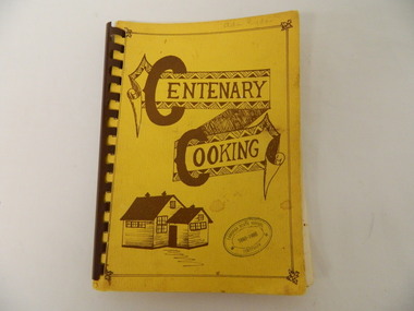
Book - Cooking x2, Centenary Cooking, 1980
The Tawonga School was a weatherboard building built on 8 acres of land catering for children from the surrounding grazing farms to ride their horses to school. It opened on 27th July 1880. The original school building and records were erased by fire in 1900. The Tawonga hall was used until 1910 when 3 acres of land was donated by Frank Cooper. It still operates today (2015) with its numbers having fluctuated over the years with the Kiewa Hydro Electric Scheme, tobacco farming and now tourism. The Tawonga community published a cook book to celebrate the school's centenary.This book may have also been used as a fund raiser.The Tawonga school celebrated its centenary with a cookbook with contributions from the community. This indicates that the school was very proud of reaching its centenary and the community co-operated with each other to develop this book.This book is a good source of the names of people who lived in Tawonga in 1980.Yellow book with brown writing and sketch of school held together with brown hard plastic binding. It has 90 pages of recipes most of which give the contributor's name.Tawonga State School Centenary 1880 - 1980 (stamped on front & back cover) In pencil on front cover: Ada Ryder An advertising for Kelvinator sticker has been stuck on the inside front cover with 18-3-92 written on it & on the inside back cover and 'Energy Rating' sticker.tawonga school. centenary of school. 1880-1980. cooking. food. kiewa valley -
 Kiewa Valley Historical Society
Folder - Family History, The Maddison Family, 1968 and later
George Maddison selected land in 1877 between the East and West Kiewa branches of the Kiewa River - known as the "Island". Now Mt Beauty.Pioneer family in the Kiewa ValleyPlastic brown folder with transparent front held by 2 gold metal slide clips. 9 clear plastic sheets holding 4 typed sheets, 3 typed sheets by Ted Maddison 1968, 4 handwritten pages in 1 plastic sleeve and 6 handwritten pages in 1 plastic sleeve (the handwritten sheets are the same as the typed sheets.)maddison family; mount beauty; kiewa valley -
 Kiewa Valley Historical Society
Folder - Clare Roper No. 7, Items of Interest
Clare Roper was a resident of the Kiewa Valley and belonged to the Kiewa Valley Historical Society.Clare Roper collected and collated items of historical interest for the Kiewa Valley Historical Society.Grey plastic front and back cover with black spiral spine with 24 clear plastic sleeves / pages plus 2 sleeves empty. Includes: Roper Family. Thomas Mitchell C.M.G.. North Eastern Dairy Company. Johann Gottfried Scholy's History. Rutherglen's Early Days.The Viticulture College. Botharambo. Pledge of Loyalty (to the Queen). North East Historical Societies. The Land Act 1883. Protection of the Aborigines 1886.clare roper; scrap book -
 Kiewa Valley Historical Society
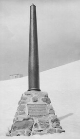
Photo: Memorial on the Staircase Spur Track, Mt Bogong
Mt Bogong is the highest mountain in Victoria. The Staircase Spur track to its top starts at Mountain Creek Road going through forest and continuing above the snow line to grass land. The weather can change very quickly with cloud and snow making conditions dangerous. Large sepia photo of the Memorial in snow on the Staircase Spur Track on Mt Bogong. The Memorial has a plaque attached: Sacred to the Memory / of Georgine Gadsden / Edward Neave Welch / John McRae / who perished here during a blizzard / about August 2nd 1943staircase spur memorial, mt bogong -
 Kiewa Valley Historical Society
Photos - King Family Collection
The King family lived in Tawonga South where my older brother and sister went to school. We lived over the road from Wally Madison's farm. Later when a house became available, we moved into Valley Avenue, Mt Beauty. This is when I turned 5 and started my schooling. It was a long walk for a 5 year old as I remember. Then later we moved to 50 Lakeside Ave. I remember we loved living there as it was close to the school, footy ground and kindergarten. My father, Ted King, wad a carpenter and was involved in the building of many houses in Mt Beauty which was the home for the workers on the Kiewa Electric Scheme. So as they are part of the history of Mt Beauty I thought they may be useful to you as part of the history. The tennis photos, I vaguely remember Lou Hoad and Ken Rosewell giving exhibition matches in Mt Beauty. I may stand corrected on this, but I do remember my parents who were keen tennis players themselves were most excited at seeing these famous tennis players. As I was only 9 when we left Mt Beauty to live in Dimboola I still remember the shock of leaving a beautiful mountainous county side and arriving in a flat farming land next to a desert and seeing windmills One thing I do remember from school is, once a week (or fortnight) the teacher used to come around with a jar of little white pills, of which we were all to take. I really don't know what they were?? or for?? I also remember being taught to swim in the freezing cold river by a Mrs Smith who wore black bathers and wore her hair in a bun...... ...I am now in my 70s My father used to also carve intricate trays and jewellery boxes in his spare time. I think they were used for tennis trophies. by Diane Werner.x33 photos of small black and white photos of the Tawonga, Tawonga South and Mt Beauty - Photos not labelled but described as follows. See each photo for a possible label. A. Tawonga? B. Mt Beauty taken on the road to Bogong ? C. SEC Works D. Industrial buildings with mountains in the background E. Building site with wooden frame and 3 men F. Buildings with power poles G. Building site with lots of huts H. Buildings under construction I. Group of houses in the distance J. Group of houses in the distance K. Group of people in front of a building L. Group of 8 men sitting on timber planks, corrugated iron at back. M.& N. Building site with floor and upright timbers O. Mountain view with camp site in foreground P.& Q. Buiding site, several houses R.5 men at a building site S. portable building on trailer T & U. Mountain view V. Building site W. Group of men, car and mountains in background X. Cows Y. Pigs Z. 2 men standing next to cars. AA. Football players BB. Man painting a corrugated iron building CC. Football DD. Men in front of a building EE Buildings with mountains in background FF & GG Tennis payersHH & II. Electricity infrastructure